Land Cover (GLCNMO) - Global version
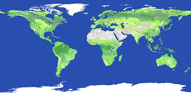
The Global Land Cover by National Mapping Organizations (GLCNMO) is geospatial information in raster format which classifies the status of land cover of the whole globe into 20 categories. The classification is based on LCCS developed by FAO. Therefore, it is possible to compare and integrate GLCNMO and other land cover data products based on LCCS.
Summary
Land Cover (GLCNMO) Global version data were developed by the secretariat of ISCGM in collaboration with Geospatial Information Authority of Japan (GSI), Chiba University, and NGIAs of respective countries and regions. The data were prepared by using MODIS data with remote sensing technology.
The data cover the whole globe in grids of 500m (15 seconds) intervals (for Version 2 and Version 3).
To date, data of three periods, i.e., Version 1, Version 2 and Version 3, were developed and provided.
| Version 1 | Version 2 | Version 3 | |
| Data source | MODIS data 2003 (Terra) |
MODIS data 2008 (Terra & Aqua) |
MODIS data 2013 (Terra & Aqua) |
| Coordinate system | WGS84 | WGS84 | WGS84 |
| Resolution | 30 arcseconds | 15 arcseconds | 15 arcseconds |
| Data type | Byte (8bits) | Byte (8bits) | Byte (8bits) |
| Bit order | Little end ordering (Intel x86) |
Little end ordering (Intel x86) |
Little end ordering (Intel x86) |
Reference
Tateishi, R., Bayaer, U., Al-Bilbisi, H., Aboel Ghar, M., Tsend-Ayush, J., Kobayashi, T., Kasimuf, A., Thanh Hoan, N., Shalaby, A., Alsaaideh, B., Enkhzaya, T., Gegentana, Sato, H. P. (2011). Production of global land cover data - GLCNMO, International Journal of Digital Earth, 4(1), 22-49, http://dx.doi.org/10.1080/17538941003777521
Tateishi, R., Thanh Hoan, N., Kobayashi, T., Alsaaideh, B., Tana, G., Xuan Phong, D. (2014). Production of Global Land Cover Data - GLCNMO2008, Journal of Geography and Geology, Vol. 6, No. 3, 99-122, 2014, http://dx.doi.org/10.5539/jgg.v6n3p99
Kobayashi, T., Tateishi, R., Alsaaideh, B., Sharma, R.C., Wakaizumi, T., Miyamoto, D., Bai, X., Long, B.D., Gegentana, G., Maitiniyazi, A. (2017). Production of Global Land Cover Data - GLCNMO2013. Journal of Geography and Geology, Vol. 9, No. 3, 1-15, 2017, http://dx.doi.org/10.5539/jgg.v9n3p1
Index Code
The following table shows 20 classifications.
| Code | Class Name | Code | Class Name |
|---|---|---|---|
| 1 | Broadleaf Evergreen Forest | 11 | Cropland |
| 2 | Broadleaf Deciduous Forest | 12 | Paddy field |
| 3 | Needleleaf Evergreen Forest | 13 | Cropland / Other Vegetation Mosaic |
| 4 | Needleleaf Deciduous Forest | 14 | Mangrove |
| 5 | Mixed Forest | 15 | Wetland |
| 6 | Tree Open | 16 | Bare area,consolidated(gravel,rock) |
| 7 | Shrub | 17 | Bare area,unconsolidated (sand) |
| 8 | Herbaceous | 18 | Urban |
| 9 | Herbaceous with Sparse Tree/Shrub | 19 | Snow / Ice |
| 10 | Sparse vegetation | 20 | Water bodies |
Use of data
Acknowledgement of written sources is necessary. Please show a text, &quat;Geospatial Information Authority of Japan, Chiba University and collaborating organizations.&quat;, on your products.
Countries which cooperated in providing training data and validation
Version 1 (40 Countries and Regions)
Afghanistan, Argentina, Australia, Austria, Bangladesh, Belgium, Botswana, Brazil, Chile, China, Colombia, Estonia, Hungary, Indonesia, Iran, Italy, Japan, Jordan, Kenya, Republic of Korea, Lao People's Dem. Rep., Latvia, Malaysia, Mexico, Niger, Nigeria, Occupied Palestinian Territory, Papua New Guinea, Romania, Sri Lanka, St Helena Island, Switzerland, Syrian Arab Republic, Thailand, The Philippines, Uganda, Ukraine, United Kingdom, Uruguay, Zimbabwe
Version 2 (14 Countries and Regions)
Botswana, Chile, Cote d'Ivoire, El Salvador, Japan, Macao, S.A.R., China, Macedonia, Mexico, Oman, Pakistan, Serbia, Sri Lanka, Thailand, United States
Version 3 (22 Countries and Regions)
Algeria, Australia, Botswana, Brazil, Burundi, Chile, Colombia, Germany, Hong Kong SAR China, Japan, Latvia, Macao SAR China, Macedonia, Madagascar, Malaysia, Mexico, New Zealand, Romania, Senegal, Sweden, Thailand, Viet Nam